Recovery Collection: the Philippines: Mount Pinatubo Eruption 1991
In the 3 years after the 1991 eruption of Mount Pinatubo, the eruption plume decreased flooding in tropical regions but increased stream gauge readings in arid areas of each hemisphere.
Introduction
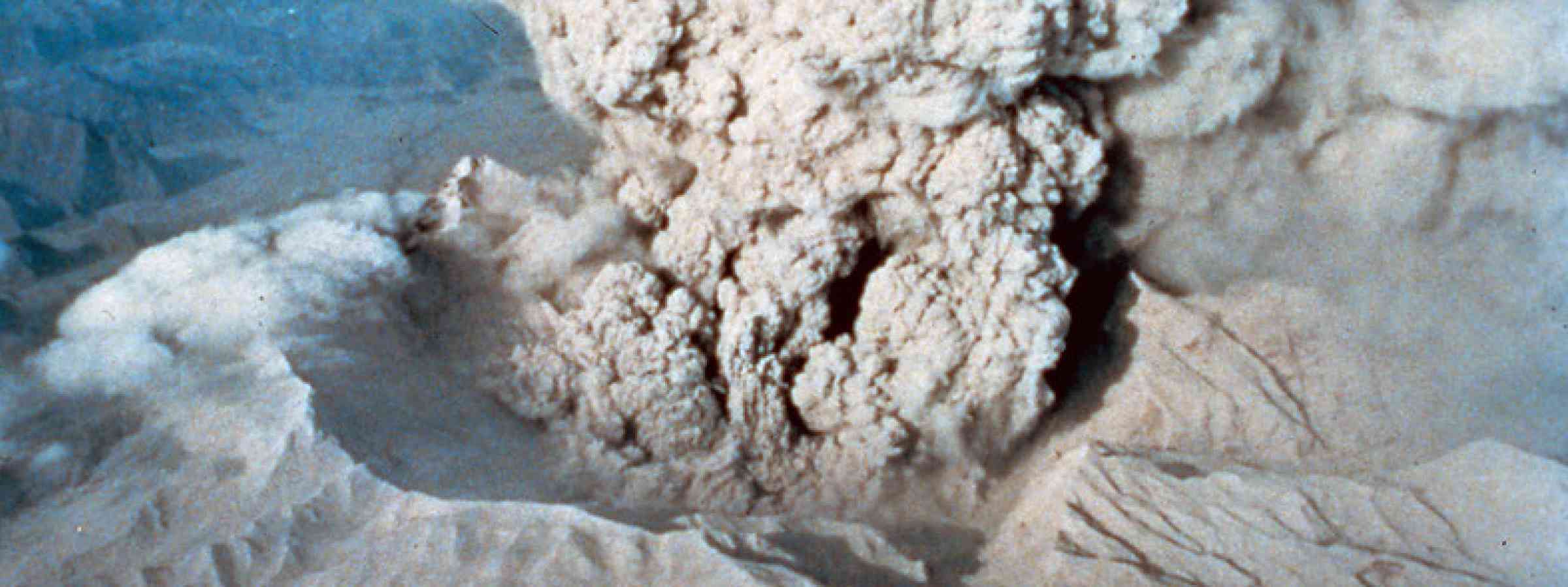
The eruption of Mt. Pinatubo in the Philippines in 15 June 1991 is considered one of the world’s largest volcanic eruptions in the past century. The eruption produced an ash cloud that rose 28 miles (40 km) into the air blanketing Central Luzon with volcanic ash and pumice. Pyroclastic flows roared down the slopes of Mt. Pinatubo creating new volcanic deposits as much as 200 meters thick. On the same day, Typhoon Yunya crossed 75 km northeast of Mt. Pinatubo with rain and high winds bringing ashfall to many areas including Manila and Subic Bay and as far away as the Indian Ocean. Between 1991 and 1993, approximately 20 million tons of sulfur dioxide were injected into the stratosphere and spread around the world temporarily lowering global temperatures by one degree Celsius.
Scientists from the Philippine Institute of Volcanology and Seismology and the United States Geological Survey had been monitoring the volcano since April 1991 and predicted the eruption, allowing for a massive evacuation to be undertaken and saving more than 5,000 lives and preventing property damage estimated at USD 250 million. Many of the deaths (over 840) and injuries from the eruption were due to roof failures caused by wet, heavy volcanic ash, which would not have happened without the typhoon. In the years that followed, the deposited volcanic ash remobilized due to rain generating secondary mudslides and damaging bridges, irrigation canals, roads, farmlands, and urban areas during the rainy season. Damage and losses resulting from the eruption and subsequent lahars were estimated at PHP 10.1 billion (USD 374 million) in 1991, and an additional PhP 1.9 billion pesos (USD 69 million) in 1992.
Memorandum Order No. 369 creating the Presidential Task Force on the Rehabilitation of Areas Affected by the Eruption of Mt. Pinatubo (Task Force Mt. Pinatubo) was signed into law in 26 June 1991. Task Force Mt. Pinatubo, chaired by the Department of Budget and Management, was mandated to guide and coordinate all rehabilitation efforts of the government, the private sector and the international humanitarian organizations. It was succeeded by the Mt. Pinatubo Assistance, Resettlement and Development Commission (Mt. Pinatubo Commission) in 1992 to 2000 which administered the initial PhP10 billion rehabilitation fund and formulated the Integrated Plan for the Mt. Pinatubo Affected Areas in July 1994 which comprised rehabilitation programs for infrastructure, livelihoods and resettlement. Non-structural measures prioritized were flood/mudflow warning and dissemination systems (i.e., warning equipment, public education about lahar hazard, and hazard mapping), resettlement and evacuation system, and livelihood support. As an ad hoc agency, Task Force Mt. Pinatubo faced issues such as confusion of roles of government agencies, lack of communication and coordination, inadequate staff and equipment, and limited financing, among others. Erosion and lahars that covered the lowlands at rates unprecedented in the history of volcanic hazards mitigation or sediment control affected many more people for a much longer period of time in the provinces of Pampanga, Tarlac, and Zambales delaying recovery in these areas. The government’s resettlement program led to cultural changes and the redistribution of the population of Aetas, an indigenous community living on the slopes of Mt. Pinatubo.
The eruption of Mt. Pinatubo broke ground in many ways changing the understanding and approach to volcanic hazards including new understanding of triggers for eruptions, the discovery that excess gas makes for more explosive eruptions, details about atmospheric circulation, evidence that humans cause global warming, the importance of effective communication, and being the first to successfully mobilize widespread evacuations. The recovery from the Mt. Pinatubo eruption provided many lessons which have informed actions by the government prioritizing preparedness and recovery from volcanic hazards in the years that follow.
References:
ADRC. (no date). Eruption of Mount Pinatubo in the Philippines. URL: https://www.adrc.asia/publications/recovery_reports/pdf/Pinatubo.pdf
Wendel, J.,Kumar, M. 2016. Pinatubo 25 years later: Eight ways the eruption broke ground. Eos 97. https://doi.org/10.1029/2016EO053889